Emphasis on "attempt". That said, I'm writing this with my infected toe and swollen legs elevated on a coffee table, safely snuggled into my girlfriend's couch in Lexington. Didn't want to give away the ending, but most of those close friends following me already know that I took a rescue home after my fourth day on the trail. So, for those of you still interested in some story and photos of this beautiful backcountry, I'll start over at the beginning...
Day 1 - Northern Terminus to Stoney Cove. (38ish miles)
 |
| At the Northern Terminus. |
The trip started days earlier with errands to outdoor stores in Louisville and making it look like Christmas morning in my little house. A bit of cushy camping gear for Emmy's first night roughing it, a few new gearhead items, a new Kentucky Atlas/Gazeteer, a digital camera and a Lifeproof phone case were all checked off the list. Those, plus my already ridiculous pile of gear and food were loaded in the Subaru Saturday evening, and Jack and I started heading East. Felt good to finally walk away from the safety net of my house. We met John who was already in Lexington and napping on Emmy's porch. Fattened up on some Bourbon 'n Toulouse and Graeter's ice cream, I busy-bodied around until way too late into Sunday morning considering our 8 a.m. trailhead eta.
Steve Barber, the Executive Director of the Sheltowee Trace Association (STA) and his other half Karen, met us at the trailhead for photos and a quick interview (which can be seen at the STA's facebook page). They were excited for us and full of questions mostly revolving around the running aspect of the endeavor, as they're already quite familiar with big hikes and the trail as a whole.
Off a little before 9, John and I tapped out the first few singletrack miles with relative ease. An unseasonably wet July had us joking if a kayak trip wasn't more logical as our feet dipped into what would usually be dry creekbeds almost immediately. I was confident, having just run this section a week or so earlier, but it was before our first road crossing at Dry Branch that I got us lost. John wanted to err on the side of caution and I kept plowing ahead until we began dropping 100's of vertical feet. Too committed to go back at that point, we just hoped that the road we popped out on might be Dry Branch or somewhere close. Well, it was close, as in it was in Kentucky. I had gotten us more than 90 minutes of hard road running away from the Trace and John really kept it together and didn't bury me in one of the countless cemeteries that we were passing (although I know he wanted to kill me).
Finally having made back to Dry Branch and our beloved trail, it was on to Morehead. We cruised through the new gates which we re-locked going through private farmland, then the trail's first suspension bridge at Holly Fork, then a big climb from the creek to the ridge and we were at the water drop that we had stashed at 799 (14 miles in). We assessed the gravity our earlier mistake (my mistake) and what realistic goals for the day were looking like. Refueled, it was down Fr-977 for the 12+ mile push to Morehead. We tapped out the miles of fire road and I called Emmy to let her know to back up her rendezvous plans 10 miles from Stoney Cove to the McD's/BP near I-64 at US 32. Following a long fire road approach, it's a 6 mile sawtooth ridgeline that punishes you all the way to US 32. I kept telling John not to get too excited about the fact that we could hear the highway as I knew it was a mirage having fallen for it a week or so earlier. The climbs steepened and rocky downs got looser as John and I both saved the need for dental repair following hard toe kicks on fast downhills. Finally, that last descent got there and we closed in on that first hook up with Emmy at McDonalds. I think John said "I've never been so glad to see those bleepin' arches" as we rolled up.
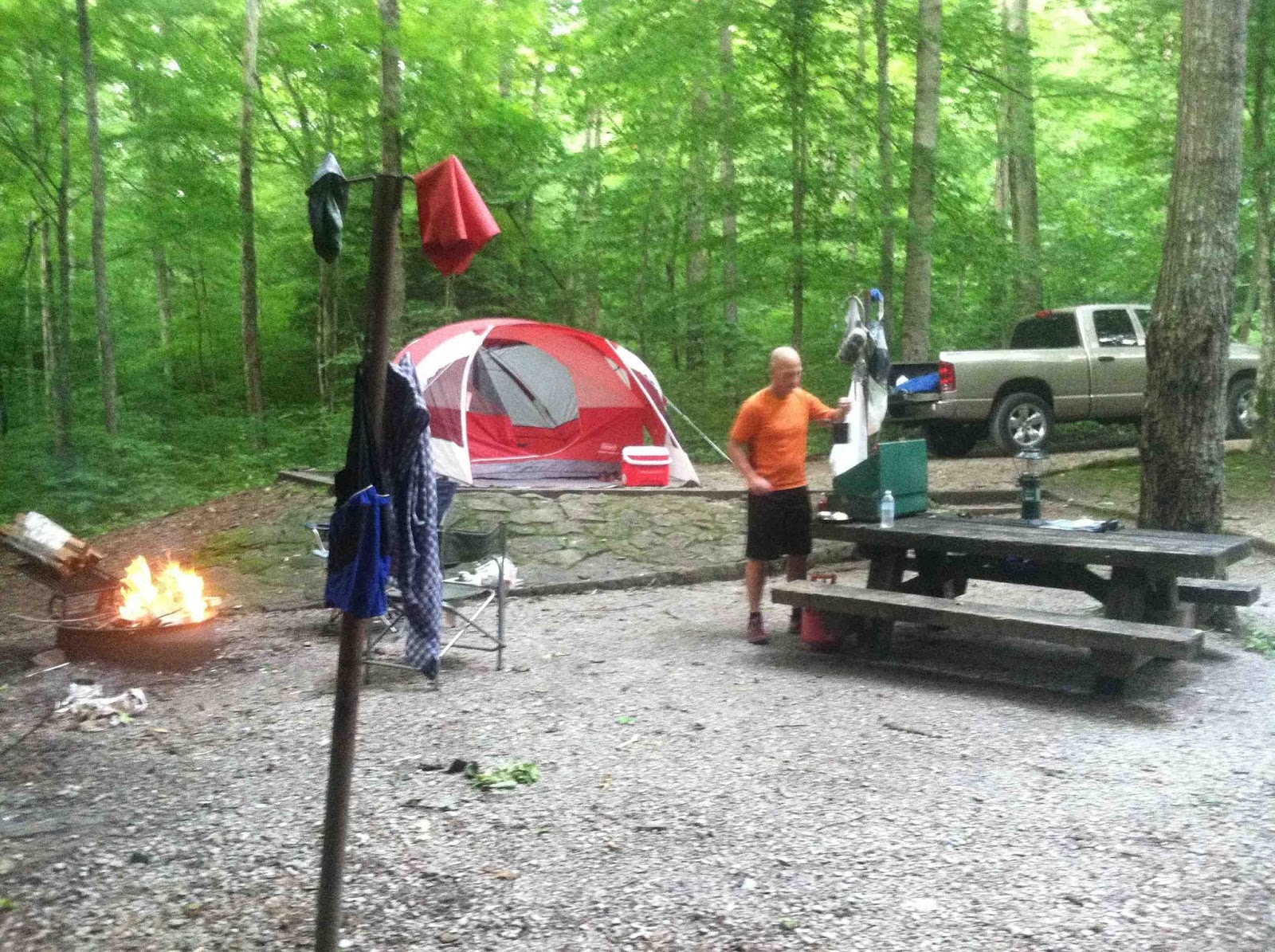
Running an extra 10 road miles to earn his 27 or so trail miles had John felling content with his effort for the day, and Emmy drove him back to the terminus as I headed on to Stoney Cove. Some very pretty (and easy) road miles are followed by some really ugly (and dangerous) road miles on US 60 then another sweet trail up and over one last big hump for the day. A quick soak in Cave Run Lake and it was off to Twin Knobs campground for Emmy's first night sleeping in a tent, at least in her adult life. Her "I love NOT camping" tote bag said it best, but she was a trooper and we enjoyed a beautiful night on the edge of Cave Run.
 |
| John crossing Holly Fork. |
 |
| 6 miles out one way or the other. |
 |
| John's last chance for a shot with the turtle blaze. |
 |
| Over Triplett Creek and into some field before the trail gets good again. |
 |
| Ahh. That was a long 38 miles. |
Day 2 - Stoney Cove to Red River Gorge. (37ish miles)
 |
| Goodbye Emmy and Stoney Cove. To the Gorge! |
Climbing out of our cushy new camping digs wasn't easy, and my departure from Cave Run didn't happen until much later than I'd like to admit. Once on the trail, it was up and out the wide multi-use rollers leaving the lake and onto some good singletrack heading into Clear Creek Lake (the previous day's tentatively optimistic goal). It took quite a bit longer than anticipated and Emmy was standing out on the road watching for me as I popped out of the woods near Clear Creek's picnic area and iron furnace. It had gotten hot, and it was a long stop before I was back on the trail for what I knew would be a hard piece into the high country heading toward Red River Gorge. The rollers gave way to legitimate climbs big exposed sandstone.
After getting lost in an area of logging or mining or something, I popped out on US 36 thanks to some good directions from local weed-eating his yard who reassured me "everybody gets messed up back there". I was supposed to come out around the corner on 1274 and Emmy drove to meet me and provided a much needed air-conditioned lift down 77 to where the trail turns off again to enter the Clifty Wilderness. Another 10 mile pull was ahead, and it looked like crossing the gorge to reach Natural Bridge SP might be a stretch. Sure enough, getting to Red River was all I had in the legs. After the long gradual downhill from the ridge, the trail gets into that groove of kicking your tail without gaining any real elevation as it dances in and out of the creases of the Clifty Wilderness. Once I finally popped out on 715, my legs were toast and the day was pretty much gone. Two days in, and I was 10 miles of Red River Gorge country away from my goal. But, I was back in Emmy's embrace and the agenda included Miguel's pizza and a night at Hemlock Lodge in Natural Bridge State Park. Could be a lot worse.
 |
| Looking back at Cave Run Lake. |
 |
| Snaking through the first BIG rocks. |
 |
| Selfie with a cool arch (the other one of these where I am not smiling makes me look like a cadaver). |
 |
| A taste of gorge country to come. |
Day 3 - Red River to Heidelberg. (31ish miles)
 |
| Ready to head over Natural Bridge. |
Having to backtrack 10ish trail miles to start my day wasn't ideal, but a good shower, sleep and all-I-could-eat breakfast at the Hemlock Lodge had me feeling pretty good. Getting food in toward the end of each previous day had been challenging at best, and I tried to be optimistic about my gastro-intestinal issues that the first 75 or so miles had put my system through. Legs weren't too bad, and I was over the suspension bridge at Red River and climbing toward Pitch 'em Tight at a good clip. Pleasantly surprised by how uneventful the trip thru the gorge was, I called Emmy when I popped out on Tunnel Ridge Road to make sure she was up from her mid-morning nap and ready to meet me at Natural Bridge's trailhead.
"That was the shortest I've had to wait yet" she exclaimed as I rolled up to the 4runner. I high-fived her and started refueling quickly with my energy levels feeling great. The state park trails were full of people for a weekday, and it made me think of the Hillary Step on Everest as a line of people waited to get through Fat Man's Squeeze on the way up to Natural Bridge's top. OK with the rest, I awaited my turn and fielded questions from the curious tourists. Even took a photo for some really nice folks on top of the arch.
I somewhat enjoyed the company as I knew the trail would quickly get much more remote once south of the park. Beautiful sandstone ridges provided good grip and better views, and they eventually give way to roads. It is in this stretch that I've seen some of the most hidden homesteads. Having pushed my next rendezvous with Emmy, Josh and Tom back to US 52 and 399 meant I had a really, really long way to go. There is little distinction between a trail, a road and a driveway though this section as all of them have sandstone peeking out and are barely wide enough for a wagon, let alone a truck. Bailed out by a water supply at Standing Rock Church, I knocked off the last section including one huge climb south of Greeley, on which I started trying my phone, knowing my crew would have been waiting for a long while. Finally I got some bars as I topped out the ridge and got ahold of Emmy who was riding around with Tom and Josh sniffing out the next section of trail. They came back toward me and let Tom out of the truck to run back toward me with a fresh bottle of water. It wasn't more than a couple of minutes before I looked up and saw Tom, trekking poles flying, coming toward me. Went a little further and looked up to see his truck. They had just dropped him off and I was almost out of the woods. Thank goodness.
It was cool to see the entire crew together and they had seemingly been having fun together, sharing stories, and figuring out where I was supposed to go from there. I called Steve Barber at that point and took a pretty long rest as I was feeling a little cooked. He told me that it was a road detour around 399 to Heidelberg, and that I was looking at about 9 miles or so to reach the blue bridge. Then it would be another big piece to Turkey Foot and the campsite that Tom had already set up. I gave big hugs and kisses to Emmy as she was heading back to Lexington after about 48 hours as my sole support person. I was in good hands as Josh drove the truck in short increments up the road waiting on me and Tom to run/walk by ready with ice cold water each time. Unfortunately, my feeling strong and adequate quickly gave way to headache, cold chills and nausea.
Having already smashed 22 or so trail miles, I felt like the rolling road down to Heidelberg was just a formality before we'd get back to business on the trail. Turned out to be nine of the longest miles of my life. About half way through the vomiting started. I was kinda glad Emmy didn't have to see me like that, and I knew that if it weren't for Tom and Josh, that I would've been in a world of hurt. Physically vomiting is not very fun, but psychologically it really messes with your ability to carry on knowing that all of your recent caloric intake and hydration needs are puddled on the road. It was all I could do to not get in the truck during those last few miles. I simply handed Tom my bottle which he would run over to Josh as I power-walked my sorry ass down the road. He would be back with me what seemed like seconds later with a refill, and I was really happy to have his companionship and Josh's cool southern "goooood job, maaaaan" every time I passed by. I made it across the blue bridge and was completely done. Now far from goal pace, it was one of the darker points in the journey. Full of uncertainty, it was a surprisingly long ride in the truck to Turkey Foot. Once there, I collapsed in the tent for some quick r and r. Tom was a gracious host and worked hard to prepare me for the next day. Time to decide what that was going to look like.
 |
| Trail through the gorge is sweet. |
 |
| Whittleton Branch Trail recent storm damage. |
 |
| Cute waterfall on Whittleton. |
 |
| RRG behind me. Feelin' good. |
 |
| View from the top. |
 |
| Tom's first big 200 meters away from the truck. |
 |
| To Heidelberg. Turned into a walking / puking affair. |
 |
| Bad shape. And short of the my goal. |
 |
| Cooked. |
 |
| Tom working hard to ready me for the next day. |
Day 4 - Turkey Foot to the 49er. (27ish miles)
 |
| South of S-tree. The first of many - big fords, not blazes. |
Tom and I spend a lot of time the night before looking over the maps and considering distances versus days left I had to play with. I made the decision to skip ahead. A thru trip it would not be. Sadly, I opted to skip the end of the previous day's section to Turkey Foot that I was going to have to backtrack for and this day's section from Turkey Foot to S-tree. Both of them I had mountain biked a lot in the past, and Steve and Karen told tales of horrible mud bogs slowing hikers to a standstill. I opted to keep my future crews heading for their original rendezvous points and leapt ahead to S-tree following a much needed stop at the Dairy Queen in McKee.
My goal for the day was simple - run little or none, get through 27 or so miles of hiking to reach I-75, recharge, re-energize, reset the system. A couple of small crossings through Raccoon Creek (I think), then it's into Horse Lick Creek, which the guidebook and the locals refer to as simply Lick Creek. My feet had been taking a beating the whole way due to the unreal amounts of water out there for mid-summer, and I was almost knee-deep in Horse Lick countless times. Met a really nice local and his family somewhere in those bottoms full of ATV trails and swimmin' holes, and he sent me in the right direction. Eventually, I popped out on 89 where Horse Lick empties into the Rockcastle, and where Tom was supposed to leave me some water before he headed back to L'ville. I wondered how long before he had been there due to the amount of ice still left on the ground on this hot day. Regardless, I was stoked to have the water and the soup, as I filled up my carrying capacity then took off down the road with a gallon in one hand and a bag of soup in the other.
89 runs into 490 at Lamero (or "marrow" as I heard a local put it) before the trail breaks off again toward Wildcat Mountain. Thinking about the previous day, I worked to down the entire gallon of water and a bag of soup during the few miles of road. The next section of trail was a nice reprieve from the blistering asphalt and turned out to be one of the prettiest and recently maintained sections that I saw. A storm rolled in shortly after I had passed all the protective overhangs, and, by the time I reached road again, I was completely soaked but feeling lucky that I had avoided all of the "widow-makers" that were blowing out of the trees everywhere for the previous hour. A friendly lady pointed me down Hazel Patch Rd., but I was really hoping she might offer up some porch. Time to make it to the 49er, and I started to run a little again. On to Wildcat Mtn Rd. on through to the historic Civil War Battle site. From there it was a mostly downhill five mile stretch to the 49er. I had a dry bag of gear waiting for me there that Tom had dropped off on his way home (well, out of his way home) and the accommodating truck stop was the oasis that I had been thinking about all day.
Once close enough to I-75 to smell the exhaust, I powered up my phone and called Emmy to let her know I was pretty much done for the day. Then I got a voicemail from Steve Barber. He was telling me that the Trace below Laurel Lake through Cumberland Falls was impassible and would have to be detoured around. That made me feel like my decision to skip a prior piece was ill advised. But, a smokey truck stop greasy spoon with showers was in sight and my cares slipped away. As I approached, I scoped out where I might camp that night with my lean-to set up, and thought about what my first dinner was going to be.
Wasn't long after I shed my shoes that one of the truckers looked down and said, "Man, you better take care of you feet or they're gonna rot off." I shrugged him off and knew that they looked worse than they felt and I always have black toenails. Shortly after my country fried steak breakfast platter was cleaned up, my shower was ready. It felt great, even if it did cost ten dollars. I think I was supposed to say that yes I was a driver. Instead, I said, "No, I'm a hiker." Regardless, I sat down and ordered dinner number two. That's when I started paying a little more attention to my right big toe. I had forgotten that I rammed it into a rock on the first day as my feet always look terrible. But, now that they had dried out, the condition became more clear. As the rest of them started to look more normal, this one looked more red, more tight, the nail more green and suddenly I realized that my flip flop was collecting a sticky ooze. What the hell?
I knocked around, called Jack (knew he'd want me to carry on), tried to call Steve (got no answer, but wanted trail updates), and called Emmy (knew she'd worry about infection in my toe and would be willing to rescue me at any hour). I burned up phone battery looking up WebMD and sending my text updates to my friends and family. Back and forth I went. Hours passed by, I hadn't moved toward camping, hadn't called for a bail out, and I was just watching my toe turn green and began to feel my pulse throb in it. Infection for sure. Within the hour, the 4Runner was rolling up and I was rolling away from the Sheltowee Trace.
 |
| Aid drop 101 by Tom Nielsen. |
 |
| Gorgeous trail behind this sign. 12 more miles to the 49er. |
 |
| Hard to tell which is the hurt one. |
 |
| That's not normal. |
I wasn't even away from the trail before I started scheming my return. Much could have gone better, many mistakes were my own stupid fault, but feeling like I was disappointing those folks rooting for me was the only part that really bothered me. I had a wonderful four days of running with great friends and beautiful, challenging trails.
The following day, my concerns were justified as everyone at the urgent care center looked wide-eyed at my feet. Was even ordered an X-ray, but felt pretty sure I hadn't broken the toe, which I hadn't. By the time I was beginning my antibiotic regiment, the ooze had turned brown and smelled like death. I think I made the right call.
Goals reset - knowing that trail is now 315ish miles long (I was planning on 280), I'll shoot for 8 days. I'll spend more recon days practicing each section. And, I'll be at the trail work day happening at S-tree in two weeks. Time to give back some time to this trail that's already given me so much. And, a HUGE thank you to my support crew. Jack, John, Tom, Josh and especially Emmy. Thank you so much. Hope no one feels like it all was for naught, and that you'll all return with me soon.
To whoever has that FKT - you still have it. I'll be back to try for it soon.


Amazing effort! Kudos for having the vision and drive to try it. Success doesn't always come first try. You'll appreciate it so much more when you do succeed.
ReplyDeleteIt was definitely not for naught! Great read and sometimes it is smarter to know when to call it a day. Can't wait to read when you go back again! Great job and great read!
ReplyDeleteLet's do this in the winter next time!
ReplyDeleteGreat effort Matt.
ReplyDeleteI've been wanting to take a shot at this for some time as well. An unplanned appendectomy knocked out my hope for an early summer attempt this year. I recently saw that the northern half map pack should be done this fall, which seems helpful. After reading about several thru-hikes, I've often wondered if a winter crossing wouldn't be easier. Other than the lack of light I've thought route finding might be easier sans leaves, ticks, snakes and bogs. I might shoot for early spring. Would love to take a shot at it with someone else for safety.